Cape Horn, South America.
I have just finished crossing the drake back to South America. It was a much bumpier ride than on the way over, but it's turns out I'm secretly part viking because I didn't take any medication and I didn't get sick. Does the quanine in tonic water keep away seasickness in addition to malaria? I conducted preliminary research.
The drake on the return was rough, and after days of getting on and off the ship, it was a harder to just sit on the ship without doing anything. Yesterday (2/15) I attended an lecture on sailor supersticions, had some of my good photographs critiqued by Jay, the NatGeo photographer, hung out with astronaut Bill Readdy (who incidentally loves my nephew), watched Madagascar, and played lots of board games.
Yesterday , my nephew and I went outside to the bow after dinner to "ride the waves." He did more of the photography and I did more of the bow riding. There were awesome waves, but of course not while I was out there...the ship bobbed alot, but I didn't get too wet.
Last night we were warned that when we hit the continental shelf it would get a bit bumpy. That was the understatement of the year. I didn't go to bed until late, and just when I was falling asleep, the ship started going wild. I could barely stay in bed. A waterbottle fell off the shelf (which has a rail), it was clanging aroudn the room, I got up to retrieve it, but it was so difficult to stand up, I almost crawled to retrieve it. I finally did fall asleep (after being in bed for hours) and when I woke up this morning, they announced it was so rough and choppy they actually diverted course (which is prob when I fell asleep).
This morning (2/16) I awoke just off of Cape Horn (roughest water in world + most shipwrecks ever) to a beautiful blue sky with land in the distance. Magnificent birds have returned to our ship as we slowly make our way to the Beagle Channel to return to Ushuaia. In fact, there are a few albatross just outside of my window as I type.
It has been a fabulous trip. Antarctica is more beautiful than I ever could have imagined; pictures just don't do it justice. But I also witnessed a fragile ecosystem, and saw birds and penguins struggling to adapt as their climate changes rapidly. If I had to pick one day that just blew the rest out of the water, it was probably cruising through the Weddell Sea, seeing the tabular bergs, their blue hue, and their reflections in clear blue water, the whales, and of course - my polar plunge. By contrast, the day at Dorian was really heartbreaking, watching the baby Gentoos struggle in the unnatural freezing rain.
Wednesday, February 16, 2011


Monday, February 14, 2011
Goodbye Penguins, Hello Whales
Lemaire Channel - Booth Island
This morning we got a special wake up call to come to the bow and watch the boat pass through the Lemaire Channel. The Lemaire Channel is a narrow passage between the peninsula and Booth Island. Its entrance is through sweeping tall mountains and glaciers, and it's dotted with icebergs. The entire channel seems out of Narnia, with it's tall mountains, glistening white snow and glaciers, and blue water. Majestic and pristine. Here's what the entrance to the Lemaire Channel looks like, Antarctic Peninsula to the left, Booth island to the right, and we sailed down the middle:

And went through many small icebergs like this onePenguin, Fur Seal, Gentoo Penguin, Humpback Whale, Lemaire Channel:

Check out the reflection of Booth Island in the channel water filled with icebergs:

We then sailed around to the other side of Booth Island where the captain anchored the ship super close to the land and I took a zodiac to shore to check out some additional penguin colonies (gentoo, adelie, chinstrap) as well as some fur seals. The best part of the morning was that I hung out with Jay Dickman, a National Geographic photographer and picked up some neat points. I also shot what I hope will be a stellar panoramic shot of the bay, including the sun peaking through the clouds, and the stunning mountains and valleys, dotted with penguins and red penguins (people). Of historical note, this bay of Booth Island is where a famous french expeditioner - Charcot - "overwintered" (to use an Antarctic term) in 1904. Our resident historian told us that his expedition not only had a daily menu with wine, but also produced great science.
Here is some of what I saw on Booth Island.
1) Red Penguins, which I found all over Antarctica:

2) Penguins who live with ocean front views:


3) Penguins walking in penguin tracks:

Back on ship we sailed in the afternoon to this incredible bay, Dallmann Bay, full of sunlight and snow covered mountain peaks. Breathtaking. We were whale watching. Primarily humpbacks. I was on the bow and using binoculars to look at a
group of three out in the distance as our captain manouvered our ship in that direction, when all of the sudden, three equally large humpbacks appeared just a few feet off of our bow.


There were so close you could see the details of their flukes with the human eye, see both blow holes, and generally get a sense for just how enormous, graceful, and awesome these whales are. They hung around our ship, checking out the giant blue whale they must think we are, for quite some time, before swimming off in to the distance. I feel very fortunate to have been able to see so many whales on this trip.
Every whale has its own unique fluke, like a human fingerprint. Here is one going for a deeper dive and I got a close look at its fluke:


That just about wraps up my trip to Antarctica. We're heading into the Drake passage as I write. A couple more interesting presentations are planned, and tomorrow there is a screening of Madagascar...I can't wait to see those penguins.
Sunday, February 13, 2011
Port Lockroy...it's finally cold
Wiencke Island - Port Lockroy; Jougla Point.
Well, I think I've now experienced the Antarctic cold. Yesterday I was lucky as we sailed throught the Weddell Sea in blue skies and a sun above. Today was windy, cold, wet, and pretty miserable. In the afternoon we were offered an excursion to Jougla Point and/or Port Lockroy. Most people opted for only the latter...stupid people, like me, went for both.
I went to Jougla point to see a gentoo rookery, but moreover to see Whale Bones and the Blue Eyed Shag. The Blue Eyed Shags were graceful, but due to awful visibility, wind which almost blew me off my feet, and horizontal hail, I wasn't quite able to see the blue around their eyes. After seeing the birds and more penguins, I walked back to the shore, and then alongside the shore so as not to disturb the molting penguins. Penguins molt for about 3-4 weeks, where they don't go to sea, but literally sit there shivering as they get new feathers. It doesn't look like fun. The smart ones seem to have chosen locations to stand where they are shielded from the wind. If you disturb them, it can set back their molt, which sets back their departure to the sea and can mean they don't make it. So I walked along the shoreline, which was full of ice.
I got to see the two giant whale bones. The bones were found on the island, but have been rearranged to look like what they once looked like inside a whale. I can't describe just how wet and cold it was. My pictures are relatively blurry since my lens was covered with drops. But I'm hoping some of the pictures came out ok.
After Jougla Point I took a zodiac to Port Lockroy to look at the Bransfield House, which is a pretty cool museum that shows how the early explorers and scientists lived. The house is intact and has some neat things, like an old grammaphone. Port Lockroy was, and continues to operate, as a British base on Antarctica. It has the best giftshop and I bought an Antarctic Tartan scarf. Take that burberry.
As an aside, the seas are pretty rough and you can see the wind sweeping across the water and the katabatics creating surges.
Cuverville Island
Gerlache Strait - Cuverville Island
(Connection is very slow, so photo markers are in, and pictures to follow)
(Updated 2/18: pictures are in)
Our planned landing for this morning was scuttled when a giant iceberg disintegrated in front of the landing area. To top that, there were katabatic winds (doesn't sound good, does it) coming off the land. Katabatic winds are caused by denser, colder air rushing down off the polar plateau toward the coast. They can get up to 320km/h. So we went to plan B, Cuverville Island.
The landing at Cuverville was interesting in that I got off the zodiac and landed in a tide pool. The tide pool area was rather large, very rocky, with red kelp. In some of the inner pools there were crustaceans (small ones) and leeches (tiny). Sitting/bathing on the larger rocks were quite a few fur seals. Penguins were marching from the snow on the mountain down to the water. I got to see how penguins clean themselves off before they head to sea for fishing. I got some interesting wildlife shots, including this fur seal.

Penguin in the tide pool:


Penguin going in for a swim:

After hanging around in the tide pool area for at least a good hour I went up the hill to walk on the snow and check out some of the Gentoo rookeries on the island. The gentoos here look better than the onces I saw at Dorian last week. But the chicks are still late so it remains to be seen how many will survive the winter.
Penguin Chicks:

My nephew climbed up behind the rookeries (not directly behind them) and went sledding down a pretty decent sized hill. Looked like fun, but i was busy snapping this penguin family:


Happy Feet:

Skua and Penguin aka Predator and Prey:

Off to Port Lockeroy (2nd attempt)...
PS - there is a blizzard outside. Crazy snow, wind at 30 knots...
Polar Plunge
Weddel Sea, Eastern Side of Antarctic Peninsula
I took a polar plunge (2/12) and now i'm a polar bear, or penguin, depending on who you ask. Saturday the ship landed at Brown Bluff, in the Artic Channel, where ppl got of to walk on a glacier, take a nice walk with 2 kinds of penguins, and see leopard seals. Some were fortunate enough to see a leopard seal eat a penguin (penguin not so fortunate).
The afternoon was absolutely fantastic. We cruised through the Weddel Sea on the eastern side of the Antarctic Pensinsula. There are thousands of "tabular icebergs," essentially huge table like icebergs that are enormous, many lengths of the ship and double the height. It was a bright, sunny, and clear day for the Antarctic and you could see the glorious blue base of each giant iceberg, the bases often far larger and certainly more detailed and intricate than what floats above the sea. Our captain took us right up to one of these giant icebergs and our bow touched it.
We also got to follow 3 separate pairs of whales - 1 Minke Whale pair and 2 Humpback Whale pairs. Awesome. Most of the time only their blowholes are out and they kind of lurk just beneath the surface. But there would be good chunks of time where they would come out and play look at our ship, and swim in tandem. Because the water was so clear you could even see them swim beneath the water. Occasionally they would come out of the water so they could flap their back tail and do a deep dive for food. Really awesome sight to see. Basically the weather was so cooperative and the scenery could not have been better.
Lisa, our fearless leader, announced that at 430 anyone who wanted to, could take a polar plunge off the side of the ship. About 20 of us idiots decided to. It was amazing. So refreshing. I stepped off the side of a dingy tied to the boat and jumped. My initial reaction was not about how cold the water was, but how salty! Then I thought it was cold. I quickly climed up a ladder, back into the dingy where Lisa gave me a towel and then scurried into the hull of the ship. Here's where the insanity part comes into play: i went again. This time there were only 5 of us who were crazy enough to do this. It was colder the second time around. Basically, you lose your first breath, but then it's all fine and you just get out. After the second plunge, we raced to the sauna to warm back up. Only my toes were cold after the second plunge...but they were very cold. Good times. If I get another chance, I would do it all again.
As soon as someone gives me a picture of my plunge, I'll post it here. Ditto for the tabular bergs and whales.
Friday, February 11, 2011
Off Course...
South Shetland Islands - King George Island - Maxwell Bay.
So I awoke this morning to a rocking ship (at 4am or so) and thought to myself, I thought we weren't moving till breakfast. Not only were we moving, but we were speeding along. I couldn't fall back asleep. I knew we weren't heading to Port Lockeroy and on to the Lemaire Channel (known for its breathtaking vistas).
At 7am, the tour leader got on the PA for the morning wake up and told us that a passenger was very sick and needed to be evacuated so we were bolting north to the nearest (15 hours away) medical station where she could get a flight to Punta Arenas and onward to Santiago.
After breakfast we got a full briefing on our trip north and the crew announced that we wouldn't be heading back south for at least another day, day and a half. People were obviously dissapointed, but most people asked normal questions and wished the patient well (some were less kind).
I attended a morning lecture on Penguins with a superb naturalist, Karen. It was excellent. Learned about all the different kinds of penguins (7 genus, 13 species), their evolution, habitat, mating, etc. They are still so cute. After lunch, I went to a great photo session, where I learned about the impossible trinity of photography: ISO, appature, and shutter speed. I hope my pictures improve. I then spent some time shooting black and whites in the bridge and hanging out there with the captain and crew.
Lisa, our fearless leader, arranged for an expedition this afternoon, albeit a non-traditional one. Maxwell Bay is located on King George Island, the northern-most of the South Shetland group, and is home to a Chilean Naval Base, Chilean Scientific Research Station, and a Russian Station. We got to visit all three, along with a Russian Orthodox Church on top of this hill. It's bolted down so the wind doesn't blow it away. I got to try out some photo techniques using gray scale and other methods. It was good to get off the boat, it was interesting, but by no means a highlight of the trip. There were a few chinstrap and gentoo penguins on island too. We have to wait here until the patient/passenger is medevaced out of the area. No updates on that yet, but presumably we will set sail sometime tonight. Although I am a bit dissapointed that we didn't continue further south, I am really impressed with National Geographic and Lisa for their professionalism and adaptability. All in all, we may luck out and head through the Antarctic Channel to make a continental landing AND see the GIANT icebergs before heading back south along the peninsula to pick up where we left off.
No pictures yet as time is short before recap/dinner. Ok, maybe one of the bridge in black and white.

Thursday, February 10, 2011
Torgersen Island & Palmer Station
Palmer Station and Torgersen Island.
Quite a busy afternoon over here for me as I went to Torgersen Island and also paid a visit to Palmer Station.
Torgersen first. It's a small rocky island filled with Adelie Penguins (pronounced adele-ee). Lately, with the warming seas and continent, they haven't been faring as well. However, this season they've done really well. The island is split in two with flags marking the midway point. Humans aren't allowed on one side to see if there is any effect on their health and survival by their interaction with humans. So far it seems there is no difference at all. If anything, the naturalist explained, humans may scare away skua birds, the penguins natural predator. And sadly, there is one thing the scientists forgot when setting up their control, the weather variable. Alas, seems this experiment might not get untainted results.
Ok, so Adelie Penguins. They are kind of the same height and build as the Chinstrap, but obviously look different. In fact, I'd say they look most like cartoon penguins. Nice white shirt with a black head and tuxedo. Unlike earlier today at Dorian, these chicks look fully matured, almost hard to differentiate from the adults and I'm sure they will do well at sea. Although we did see one carcass picked clean by a skua.
Here's an Adelie:

And here's an Antarctic Fur Seal that I saw on Torgersen:

After about an hour on the island we took zodiacs to Palmer Station, the US Antarctic Program's base on the Antarctic Peninsula. There are two other USAP locations, including one on the South Pole. Palmer Station houses many different scientific projects and experiments (I got to check out a few poster boards) and they have everything they need brought in once a month on a big ship (including all the most recent magazines, movies, etc). They work about 9 hours a day, seven days a week. They have a small gym, home media center, hot tub, sauna, and high speed internet. It's kind of crazy to see this all so far away from everything. Only about 1/3 of the people there stay over the winter. The rest go north. They also have this crazy tradition that whenever someone departs the Station at the end of their time there, everyone lines up on the pier and they all jump into the polar water. crazy. but fun.
I got to interact with some of the researches at the Station and payed a visit to the gift shop (no kidding, and they take credit card). I can't believe you can pay with credit card here. Still in shock.
We were quite lucky to be able to get a visit to Palmer Station. There are something like 43 ships that operate with tourists during the season (each running multiple cruises). Palmer allows roughly 12 visits per season, so everyone on board feels quite lucky to be able to see this outpost of science.

Anyhow, I'm back on board. Warming up. It was really windy out there today. Would love some comments...
Dorian Bay and Gentoo Penguins
Antarctic Peninsula - Wiencke Island - Dorian Bay.
This is a short post for my excursion this morning (10 Feb 2011). The ship is moored in Dorian Bay, a cover on the NW side of Wiencke Island, which is located in teh Palmer Archipelago. First we took a zodiac tour of part of the bay and saw some awesome icebergs (one looked just like an iguana/lizard). After puttering on our zodiac we made our way to the landing site, which was slick and rocky. Weather conditions - freezing rain - made3 the landing this am a bit trickier than usual, but thanks to non-slip pads, everyone made it on and off land just fine.
On land there is a Gentoo Penguin Colony. I got some great shots of the gentoos (bigger than chinstraps, white earmuffs). Unfortunately, this is not the year of the Gentoo. Gentoos have been doing really well over the last 20 years as the water and land around here have warmed. Normally, Antarctica doesn't get much precipation, it's an ice desert. However, the naturalist told me that there was a lot of snow this year (unusual) so the Gentoos couldn't make their nests until late. What I saw today was the result of that; a lot of baby penguins shivering in the cold freezing rain without their coats to survive, many of whom will not survive once fall arrives here shortly. A lot of the baby penguins were abandoned. Some were being well tended to by both parents. One sitting on top of the two chicks and one running off and gathering food or rocks to build a better nest. I got some great shots of this. Sadly, I also saw quite a few broken eggs laying around and some dead baby penguins. The healthier ones that I saw should survive. There was one woman on my zodiac trip back to the ship who kept on asking couldn't anything be done to save them? Basically, no. Gentoos only care for their own children and won't tend to others.
Another interesting thing I noticed was that the distance between two nests in generally no longer than the distance between respective mothers/fathers beaks. They poke at each other, but no one can harm the others children.
Iguana Iceberg:

Gentoo Penguins:


Wednesday, February 09, 2011
Deception Island
South Shetland Islands - Deception Island - Bailey's Head.
Greetings from Antarctica, well an island just off the continent anyway. I woke up this morning to thick fog so I wasn't able to see land from the get go. However, as we got closer to the South Shetland Islands I was able to see a lot more. Suprisingly, a lot of what I saw was not tundra, but lush. I guess that's the 5% or so of the continent that isn't frozen.
I spent the morning decontaminating my outer clothing to make sure I don't carry anything from other environments into Antarctica's fragile ecosystem. I also attended a talk about conservation and science efforts on some of these islands, how they have been tracking various penguin colonies, and the effects of climate change on their breeding patterns.
Yesterday the head of the tour mentioned that we would be landing this afternoon, but that our location wouldn't be known until closer to the actual landing time. Ideally, they wanted us to land at Bailey's Head, home to 100,000 PAIR of Chinstrap Penguins (named for the black stripe that goes from their ears around their chins), but it required very calm waters since it would be a difficult landing (they have only landed there once this whole season). We lucked out and after lunch I boarded a zodiac with my nephew for Bailey's Head, Deception Island. Hurray for calm seas!
Deception Island is an active volcano, and the sand was ashen and grey. Immediately to my left and right after landing were seals - Fur Seals and 1 Elephant Seal. Apparently the fur seals are not only enormous, but can also run 35mph. Also, they are not nice. Scary seals. 200,000 penguins is a lot of penguino. And Guano. AKA Penguin Poop. The island smells, is pretty noisy since there are a lot of shouting penguins, but that all faded into the background as I took in the sight of all these penguins.
We walked through a valley filled with penguins going to and from the ocean. It's feeding time. The chinstrap babies were already able to walk around, but the parents are really hungry and as the children grow they need more food. It's quite a commotion to see the penguins waddling to and from the water to get mouthfuls of krill. I was fortunate enough to see a few instances of actual feeding...saliva and all. I'll put up a picture or two of that.
All along the valley and up into the mountains on three sides are tons of penguins. An occasional Skua (bird, predator, likes baby penguins) would come swooping down and all the penguins would shriek and fight back. Occassionally while walkinig I spotted a penguin carcass. I walked up to the ridge where I could see the entire valley, speckled in black and white with the ocean behind it all. Of course if I turned around, I was at the edge of a cliff, with the ocean below me there as well.
This is a picture of seals hanging out peacefully with penguins.

This picture should give you an idea of how many penguins there are here. This is nothing compared to what I saw today. Just a tiny swath of a huge island.

This is a picture of a parent feeding a child. I feel really lucky to have snapped this one.

Finally, this is a penguin stretch.

Tuesday, February 08, 2011
The End of the Earth - Tierra del Fuego and Drake Passage
Hello from the Drake Passage. I think we had 15-20 foot sweels last night, but other than waking up from the rocking, I'm ok. I am not sea sick, which is a positive, but druing the daytime all the rocking makes me want to sleep. I'm fighting the urge with cappuchino, but am fairly certain the sea will win out. The voyage thus far has been very enjoyable. I've attended some lectures on plate tectonics, birds, how to better use my camera, etc...all in preparation for our expected landfall on Antarctica tomorrow morning. I also learned how to abandon ship, a skill I hope I will not need.
There are some awesome birds that keep trailing the ship, Albatross (many varieties), Great Petrel, and a few others. I'm attaching some photos so you can see what I'm seeing.


Just to bring you up to speed. I landed in Santiago on Sunday morning and took a quick tour of the city in the afternoon, stopping in to se the Pre-Columbian Museum, which had some very interesting pieces of artwork. My favorite was this Incan string/rope piece which was used to count and record virtually everything, from food to population, productivity, and so much more. Unfortunately, the picture didn't come out great because of the glare.
On Monday we took a charter flight from Santiago, Chile, to Ushuaia, Argentina, the southern-most city in the world. It's located in Tierra del Fuego (or Fireland) and is at the base of the Andes, where the mountains literally just pop out of the water. Best part of the plane ride had to be about 10 minutes before landing when they announced "we will now be spraying the cabin with insecticide, this will cause you no harm." Creepy.
Once in Ushuaia We took a bus to the National Park there, got off to scope out some scenic views, and then took a catamaran ride from the national park into the harbour in Ushuaia. While approaching the harbour, there was a lot of debate about which of the two large ships docked in the port was ours. I voted for the smaller of the two. However, once we go close, we noticed that ours was in fact hiding between the smaller of the two and roughly 10% of its size. Our boat is tiny compared to a cruise ship.
Tomorrow we are set to land on one of the outer islands of Antarctica and I hope to see my first penguin, but for now, that's all. Enjoy the pictures, sorry there isn't more, but as you may suspect - internet in this part of the world is rather limited.

Friday, January 08, 2010
It's a small world
This was originally posted on my friend Anna's blog, http://www.dailydoseofanna.blogspot.com/. From time to time she has guest bloggers, and I was lucky enough to be one. Check out her blog, it's cool. Anyhow, this piece is being republished here, but the original can be found here.
----
So first off, let me say that I'm pissed at Aerolineas Argentina. I got to the airport this morning to fly from El Calafate to BA, and they had a) overbooked the flight to start with and b) changed equipment to a smaller plane. Consequently, Strategerist did not make it on her flight. The good news is that there is free wifi and a place to vent. I tried every trick in the book to get on the flight and nothing worked. I asked for compensation, they refused. I stood at the counter and refused to move. In the end, I got a voucher for lunch. Small victories.
So I'm sitting in the airport lounge, and I find the ONE outlet to plug my ghetto ancient computer in to. And I'm happily logging on and all that and suddenly I have the urge for a cafe con leche. So I turn to these two guys in the corner of the cafe playing scrabble and ask them to watch my computer. I notice that they have a lot of Z's on the board, so I ask them where they are from. Poland, they respond. One from Warsaw, one from Krakow. And I get so freaking excited. I tell them that I have visited Poland, but that's not why I'm excited. I'm excited, because there was some measure of divine fate earlier in the day...
I was packing my bags and trying to organize my stuff. I was pulled my ipod out of a plastic bag, and it kind of got stuck. So I pull harder and I see something attached/hanging off of the earbud. I was pissed that I had broken it or something like that (wouldn't be the first time I've crushed those earbuds). Anyhow, it was my Solidarity pin (Solidarnoss) that I picked up in Poland in June 1989. It is my absolute favorite souvenir in the world. I've written essays on this pin. And here it was, in some random bag in Argentina. And I was pissed at myself because it should not have come and I'm not sure how it got to Argentina or mixed in with my stuff. So I put it away in my laptop bag, figuring this was the safest place for it.
So when I meet these two Poles and we start talking about Poland, I suddenly remember the pin; I dart to my bag, pull it out, and show it to them. They were more than impressed and asked me how I got that. I explained that my family took a vacation to Poland, Czechoslovakia, Hungary, and Romania in the summer of 89. They looked at me and said, 1989? Like they needed reassurance that I wasn't a lunatic. I insisted it was 89 and that's how I got the pin. Then they wanted to know what kind of family takes their vacation in the Soviet Bloc? Answer: the kind that produces a child who thinks Patagonia, Central Asia, and other remote places are fun!
Thursday, January 07, 2010
Fingerpainting
I decided today (Thursday) that I needed a bit of culture to counterbalance the outdoor activities I've been doing since arriving in Patagonia. My muscles may also have needed a break after the horse trek/ice trek combo. So I figured, what can be more cultured that fingerpainting!
I went first thing this morning to see the Walichu caves just outside of El Calafate. The caves have 4,000 year old fingerpaintings. You know, cave drawings/paintings. Some hand prints and some other designs.

I think in this one you can more clearly see the "negative hands" with the white print with red outline. My guide called the upside down ones negative, and I certainly don't know that's not what they're called. These ones are made by putting your hand on the rock (and they chose good rock to do it on as there were many types in these caves) and then using guanaco blood to paint all around it. Guanacos are related to llamas and camels and are essentially wild llamas. Although I have been on the lookout for them, I haven't seen any yet. And I doubt I'm going to find any in BA.

Here are some fingerpaintings of people. They seemed to be of the stick-figure school of fingerpaint. The really tall one on the left is the shaman.

 Some paintings of caves maybe? And then lots of dots in a circle.

After visiting the caves, I went to check out the regional museum in Calafate. I had been told it was small and quite good. Both accurate descriptions. It had an exhibit on all of the extinct big mammals and mega-animals (that is not what they were called, but that's what I'm calling them). They had some cool bones and fossils on display. Like a mini natural history museum. 
I went first thing this morning to see the Walichu caves just outside of El Calafate. The caves have 4,000 year old fingerpaintings. You know, cave drawings/paintings. Some hand prints and some other designs.

I think in this one you can more clearly see the "negative hands" with the white print with red outline. My guide called the upside down ones negative, and I certainly don't know that's not what they're called. These ones are made by putting your hand on the rock (and they chose good rock to do it on as there were many types in these caves) and then using guanaco blood to paint all around it. Guanacos are related to llamas and camels and are essentially wild llamas. Although I have been on the lookout for them, I haven't seen any yet. And I doubt I'm going to find any in BA.

Here are some fingerpaintings of people. They seemed to be of the stick-figure school of fingerpaint. The really tall one on the left is the shaman.

 Some paintings of caves maybe? And then lots of dots in a circle.

After visiting the caves, I went to check out the regional museum in Calafate. I had been told it was small and quite good. Both accurate descriptions. It had an exhibit on all of the extinct big mammals and mega-animals (that is not what they were called, but that's what I'm calling them). They had some cool bones and fossils on display. Like a mini natural history museum.
Then came the best sign in the exhibit. Apparently there is a heated scientific debate on the domestication of the guanaco. Enough to merit an asterisk. I mean, this could have wide ranging implications today, don't you think?

And because I'm a sucker for scenery: Here are some photos from where the caves are. It's got the steppe, Lake Argentina, and the Andes. I couldn't resist.


I WALKED ON WATER!
Yup, I did. Some of it frozen, other times there was water on top of ice, and I walked on it. It was definitely one of the most awesome days of my life.
Wednesday was a great day. I signed up for Helios y Aventura's "Big Ice" trek. It's about a 7-8 day of hiking, half on Perito Moreno Glacier, and half on terra firma. I found the later to be more difficult than strapping on some crampons and climbing on ice, although that did present some challenges as well. We started out the day in Calafate and drove the 90 minutes to the glacier. We walked along much of the same path I walked on Monday, taking a look at the northern wall of the glacier. I'm glad I spent a full day there though, because that enabled me to watch the calving, and really enjoy it. This was just a quick walk through the balconies, with a short stop or two for photographs. I did, however, have the chance to see three condors (3 days of the condor?).

After visiting the glacier and walking along the path, we headed for the dock to catch a boat along the eastern/southern face of the glacier, across a lake, to get to the land so we could hike up alongside. There were some crazy pieces of ice in the water.

We started hiking through a forest trail that brought us right up close with where the glacier begins.
 We climbed the side of the glacier, probably a 300 to 400m gain in elevation, in a bit under 90 minutes. Nothing too crazy, but there were some very steep parts. We stopped along the say to pick up our crampons and then to get into our harnesses. We were not attached to one another, but it was so that if we fell into some crevasse, we could be lifted out easily (that is if we didn't drown or freeze first, I was a bit pessimistic about the utility of these harnesses, but I wasn't about to go without one).


 We climbed the side of the glacier, probably a 300 to 400m gain in elevation, in a bit under 90 minutes. Nothing too crazy, but there were some very steep parts. We stopped along the say to pick up our crampons and then to get into our harnesses. We were not attached to one another, but it was so that if we fell into some crevasse, we could be lifted out easily (that is if we didn't drown or freeze first, I was a bit pessimistic about the utility of these harnesses, but I wasn't about to go without one).
We reached the ice roughly 90 minutes into our trek and stopped to put on our crampons. Then I got a mini-lesson in how to walk uphill, downhill, and traverse. And then it was off the races. I was in a group of 10 English speakers and we spent the next 4 hours together on top of Perito Moreno.


We went in and out of ice tunnels,

checked out deep crevasses (this one filled with water and extremely deep),

rivers full of water,


rivers full of water,


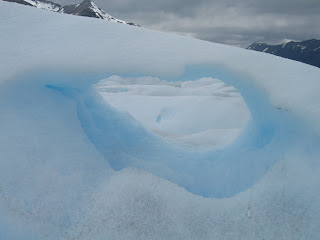
explored ice caves (that's my guide cutting out a tunnel to crawl underneath and then lift ourselves into the cave using a pick),  with a shade of blue I've never seen before (the inside of this cave was the most marvelous thing I have ever seen),
 and saw one enormous sink hole (video to be posted separately).

The four hours on top of the glacier were incredible. It was just me and glacier (and a few other people), but total solitude and isolation. It was windy, but we had decent weather, with the sun shining on occasion. I had lunch on top of the glacier with the best view ever and some very fresh, very cold glacier water. Take that evian. You have to wear gloves on the glacier, because the ice is as sharp as glass and if you put your hands on it, you will get cut and bleed. Because of the large amount of water on the surface of this glacier, there are numerous sink holes, which carry the water to the bottom of the glacier. All the water on the bottom is what's responsible for the glacier moving approximately 2-3 meters daily...which causes the glacier to calv. The glacier formation from the top is unique. It's like there are strips of river/glacier that sort of connect to one another, but there are often gaps in between. (If you saw Maya Lin's Systematic Landscapes exhibit at the Corcoran in 2009, you may have an idea of what I'm talking about). In any case, it was topographically and geographically fascinating and I have tons of good pictures. I was tired after my four hours on top and from wearing crampons, but I didn't want to go. 
 with a shade of blue I've never seen before (the inside of this cave was the most marvelous thing I have ever seen),
 and saw one enormous sink hole (video to be posted separately).

The four hours on top of the glacier were incredible. It was just me and glacier (and a few other people), but total solitude and isolation. It was windy, but we had decent weather, with the sun shining on occasion. I had lunch on top of the glacier with the best view ever and some very fresh, very cold glacier water. Take that evian. You have to wear gloves on the glacier, because the ice is as sharp as glass and if you put your hands on it, you will get cut and bleed. Because of the large amount of water on the surface of this glacier, there are numerous sink holes, which carry the water to the bottom of the glacier. All the water on the bottom is what's responsible for the glacier moving approximately 2-3 meters daily...which causes the glacier to calv. The glacier formation from the top is unique. It's like there are strips of river/glacier that sort of connect to one another, but there are often gaps in between. (If you saw Maya Lin's Systematic Landscapes exhibit at the Corcoran in 2009, you may have an idea of what I'm talking about). In any case, it was topographically and geographically fascinating and I have tons of good pictures. I was tired after my four hours on top and from wearing crampons, but I didn't want to go.
Eventually we made our way from the center of the glacier (where it's less craggy and has smoother hills - in fact, you can see this part of the glacier in some of the previous pictures I've posted) back to the edge. There we crampoffed (not a word, I just invented it now) and made our way back down the mountain. We hung around watching the glacier calv some more, and I got to see a pretty big chunk fall into the lake and some decent size waves flow out.
The boat picked us up to bring us back to our bus so we could return to Calafate. They had a very nice surprise for us...whiskey on the rocks...that is glacier ice!

Subscribe to:
Posts (Atom)